I had planned to go to Reed’s Gap via the Blue Ridge Parkway for my hike to Three Ridges, however the recent snow storm had closed the parkway. After maneuvering around the countryside, I finally arrived at Reed’s Gap about a half hour behind schedule.
The trail route follows the Appalachian Trail over several mountain peaks, along a ridge line and down into the valley near the base of The Priest. The route turns off the AT, onto the Mau-Har Trail, to climb back up to an earlier point on the AT and the return trip to Reed’s Gap.
The climb up from Reed’s Gap began with a slight incline along the tree line, exposing some decent views toward the west. The trail entered the forest and became much steeper. The trail was covered in snow and ice, making climbing more difficult, especially during the steeper portions.

The trail reached the summit of the first mountain (Meadow Mountain) in a little less than a mile. Meadow Mountain was surprisingly tree covered, but offered one clear vantage point toward the southwest. The trail descended down for nearly another mile before reaching the top of the Mau-Har Trail.
I continued on the AT over Bee Mountain. Luckily, Bee Mountain was void of Bees during this time of year. After descending a couple hundred feet from the top of Bee Mountain, the trail hugged the side of the mountain as is steadily climbed up toward the highest of the Three Ridges.
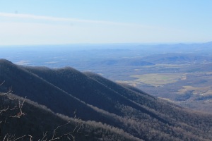
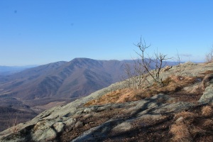
 After more than a mile of climbing, the trail opened up to a rocky outcropping that yielded the best views of the hike. The Priest could be seen toward the south and the Three Ridges toward the southeast. The top of the Three Ridges was still over a half mile away.

The top of the Three Ridges did not yield any impressive views, but there were several viewpoints from the AT on the climb down along the ridges. The first view was just below the summit. The trail snaked back and forth through numerous switchbacks before arriving along the ridge line.

The middle ridge summit (named Chimney Rock) was very rocky with and extremely large and very square shaped rock protruding from the ridge. The area yielded descent views.
There were two other decent views from rocky areas along the ridges before the trail began another steep decent through a series of switchbacks (the second view was actually during the series of switchbacks). The trail continued downward toward Harper’s Creek. A shelter rests alongside of Harper’s Creek.
The Mau-Har Trail branches off the AT shortly after Harper’s Creek. The first half mile or so of the Mau-Har was fairly flat. But the trail became very steep and climbed over a ridge before descending downward toward Campbell Creek.
The Mau-Har Trail passes by a waterfall (but there were many trees in the way and it would have been a tough climb to it) and over a very small waterfall (above it and below it). But the sights of the Mau-Har Trail did not begin until it reached Campbell Creek.
The Mau-Har Trail reaches Campbell Creek just above the first waterfall. This waterfall (the biggest of the three main waterfalls) was about 50 or 60 feet high. The melting snow and overall wet winter made the creek and its numerous waterfalls flow quickly and powerfully over the rocks.


Just above the lowest waterfall lies a second waterfall (probably 30 feet or so). This fall, the least photogenic of the three, was still a very nice fall to see.


The third waterfall was a 25 or 30 foot cascade. It was easy to stand in front of this fall to get great photos and the banks of the cascade were lined with mountain laurel bushes. This cascade would make awesome photographs while the bushes are in bloom (usually early June).

The climb up was steep with several switch backs before arriving at the AT Trail again (with over a mile and a half to go till Reed’s Gap). After struggling up Meadow Mountain again, I was able to coast down the other side, alongside the tree line to my waiting car.
All in all, a great hike. The views were very good. The waterfalls were excellent. The trail was extremely tough though. The continuous up and down of the terrain easily wore me out.
Three Ridges Trail / 13.1 miles / 3,960 feet elevation gain
http://www.everytrail.com/view_trip.php?trip_id=2055149